USGS 02322800 SANTA FE RIVER NR HILDRETH FLA

PROVISIONAL DATA SUBJECT TO REVISION

Click to hidestation-specific text

This gage is monitored in cooperation with the Suwannee River Water Management District.

Link to the Suwannee River Water Management District

REMARKS.--Computed discharge at this station may differ from individual measurements because of changes in tidal influence, wind, or other factors.
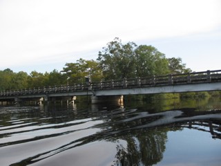

January 3, 2002.

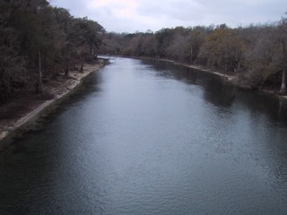
High water on October 19, 2004.
Available Parameters Available Period
  
2015-09-02  2024-03-28
2007-10-19  2024-03-28
2007-10-01  2024-03-28
2015-09-02  2024-03-28
2014-10-01  2024-03-28
2023-11-29  2024-03-28
2012-09-27  2016-09-30


 (7)
 

  -- or --


Summary of all available data for this site
Instantaneous-data availability statement


Discharge, cubic feet per second

Most recent instantaneous value: 1570 03-28-2024   07:00 EDT
Graph of  Discharge, cubic feet per second

Add up to 2 more sites and replot for "Discharge, cubic feet per second"

?


Create presentation-quality / stand-alone graph.   Subscribe to WaterAlert      

See this graph on the Monitoring Location Pages


Daily discharge, cubic feet per second -- statistics for Mar 28 based on 21 water years of record more
Min
(2001)
25th
percen-
tile
Most Recent
Instantaneous
Value Mar 28
Median Mean 75th
percen-
tile
Max
(2022)
589 1240 1570 1630 1770 2160 3860


Gage height, feet

Most recent instantaneous value: 13.13 03-28-2024   07:00 EDT
Graph of  Gage height, feet

Add up to 2 more sites and replot for "Gage height, feet"

?


Create presentation-quality / stand-alone graph.   Subscribe to WaterAlert      

See this graph on the Monitoring Location Pages