USGS 02368500 SHOAL RIVER NR MOSSY HEAD, FLA.

PROVISIONAL DATA SUBJECT TO REVISION

Click to hidestation-specific text

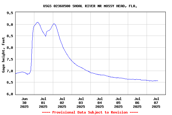
This gage is monitored in cooperation with Okaloosa County, Florida.

Link to the Okaloosa County, Florida.

Available Parameters Available Period
  
2000-05-12  2024-04-16
2007-10-01  2024-04-16


 (7)
 

  -- or --


Summary of all available data for this site
Instantaneous-data availability statement


Discharge, cubic feet per second

Most recent instantaneous value: 164 04-16-2024   16:15 CDT
Graph of  Discharge, cubic feet per second

Add up to 2 more sites and replot for "Discharge, cubic feet per second"

?


Create presentation-quality / stand-alone graph.   Subscribe to WaterAlert      

See this graph on the Monitoring Location Pages


Daily discharge, cubic feet per second -- statistics for Apr 16 based on 50 water years of record more
Min
(2012)
25th
percen-
tile
Most Recent
Instantaneous
Value Apr 16
Median Mean 75th
percen-
tile
Max
(2014)
49.6 155 164 203 314 390 1090


Gage height, feet

Most recent instantaneous value: 7.11 04-16-2024   16:15 CDT
Graph of  Gage height, feet

Add up to 2 more sites and replot for "Gage height, feet"

?


Create presentation-quality / stand-alone graph.   Subscribe to WaterAlert      

See this graph on the Monitoring Location Pages