USGS 12413000 NF COEUR D ALENE RIVER AT ENAVILLE ID

PROVISIONAL DATA SUBJECT TO REVISION

Click to hidestation-specific text
NF Coeur d'Alene River at Enaville, ID - USGS file photo

> NWS River Forecasts

> Rating Information

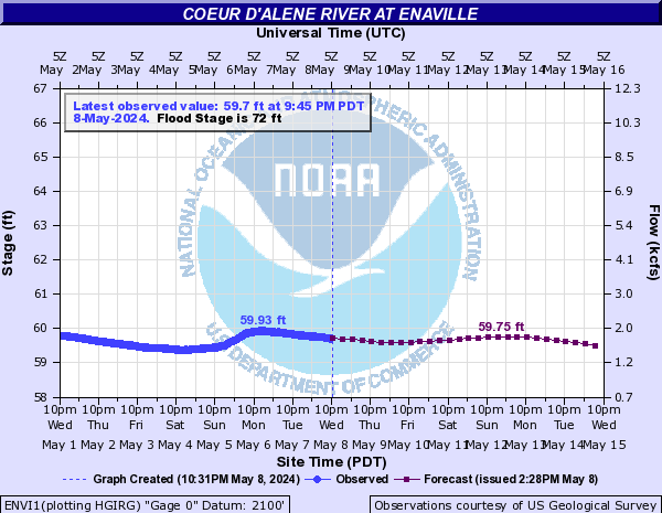
Station operated in cooperation with U.S. Army Corps of Engineers, Shoshone County, and the U.S. Environmental Protection Agency (EPA) with additional funding provided by the U.S. Geological Survey Groundwater and Streamflow Information Program (GWSIP).

This station managed by the Post Falls Field Office.

Available Parameters Available Period
  
1986-10-01  2025-07-07
2007-10-01  2025-07-07


 (7)
 

  -- or --


Summary of all available data for this site
Instantaneous-data availability statement


Discharge, cubic feet per second

Most recent instantaneous value: 377 07-07-2025   08:45 PDT
Graph of  Discharge, cubic feet per second

Add up to 2 more sites and replot for "Discharge, cubic feet per second"

?


Create presentation-quality / stand-alone graph.   Subscribe to WaterAlert      

See this graph on the Monitoring Location Pages


Daily discharge, cubic feet per second -- statistics for Jul 7 based on 87 water years of record more
Min
(2015)
Most Recent
Instantaneous
Value Jul 7
25th
percen-
tile
Median Mean 75th
percen-
tile
Max
(2011)
269 377 538 736 795 1050 1780


Gage height, feet

Most recent instantaneous value: 57.35 07-07-2025   08:45 PDT
Graph of  Gage height, feet

Add up to 2 more sites and replot for "Gage height, feet"

?


Create presentation-quality / stand-alone graph.   Subscribe to WaterAlert      

See this graph on the Monitoring Location Pages