USGS 13120500 BIG LOST RIVER AT HOWELL RANCH NR CHILLY ID

PROVISIONAL DATA SUBJECT TO REVISION

Click to hidestation-specific text
Big Lost River at Howell Ranch near Chilly, ID - USGS file photo USGS Idaho Water Science Center celebrating more than 100 Years of streamgage Records

> Rating Information

> NWS River Forecasts

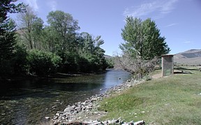
Station is operated in cooperation with the Idaho Department of Water Resources (IDWR), Big Lost Irrigation District, and U.S. Department of Energy.

This station managed by the Idaho Falls Field Office.

Available Parameters Available Period
  
1987-04-14  2025-07-14
2007-10-01  2025-07-14


 (7)
 

  -- or --


Summary of all available data for this site
Instantaneous-data availability statement


Discharge, cubic feet per second

Most recent instantaneous value: 200 07-14-2025   03:00 MDT
Graph of  Discharge, cubic feet per second

Add up to 2 more sites and replot for "Discharge, cubic feet per second"

?


Create presentation-quality / stand-alone graph.   Subscribe to WaterAlert      

See this graph on the Monitoring Location Pages


Daily discharge, cubic feet per second -- statistics for Jul 14 based on 116 water years of record more
Min
(1934)
Most Recent
Instantaneous
Value Jul 14
25th
percen-
tile
Median Mean 75th
percen-
tile
Max
(1995)
90.0 200 261 520 579 750 1780


Gage height, feet

Most recent instantaneous value: 1.31 07-14-2025   03:00 MDT
Graph of  Gage height, feet

Add up to 2 more sites and replot for "Gage height, feet"

?


Create presentation-quality / stand-alone graph.   Subscribe to WaterAlert      

See this graph on the Monitoring Location Pages