USGS 13213000 BOISE RIVER NR PARMA ID

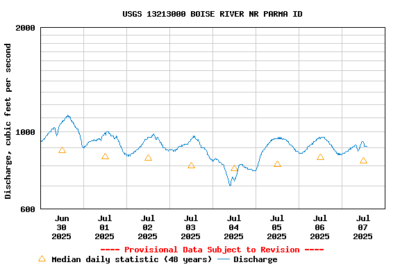
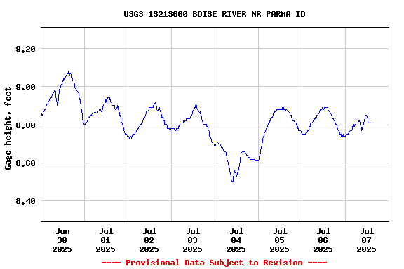
PROVISIONAL DATA SUBJECT TO REVISION

This station managed by the Boise Field Office.

Available Parameters Available Period
  
2008-10-17  2025-07-07
1986-10-01  2025-07-07
2007-10-01  2025-07-07
2008-10-17  2018-10-17
2008-10-17  2018-10-17
2008-10-17  2010-10-20
2008-10-17  2010-10-20
2008-10-17  2018-10-17


 (7)
 

  -- or --


Summary of all available data for this site
Instantaneous-data availability statement


Temperature, water, degrees Celsius, [(2)]

Most recent instantaneous value: 22.2 07-07-2025   14:00 MDT
Graph of  Temperature, water, degrees Celsius, [(2)]

Add up to 2 more sites and replot for "Temperature, water, degrees Celsius, [(2)]"

?


Create presentation-quality / stand-alone graph.   Subscribe to WaterAlert      

See this graph on the Monitoring Location Pages


Discharge, cubic feet per second

Most recent instantaneous value: 908 07-07-2025   14:00 MDT
Graph of  Discharge, cubic feet per second

Add up to 2 more sites and replot for "Discharge, cubic feet per second"

?


Create presentation-quality / stand-alone graph.   Subscribe to WaterAlert      

See this graph on the Monitoring Location Pages


Daily discharge, cubic feet per second -- statistics for Jul 7 based on 48 water years of record more
Min
(2021)
25th
percen-
tile
Median Most Recent
Instantaneous
Value Jul 7
75th
percen-
tile
Mean Max
(1982)
291 503 825 908 1080 1120 6310


Gage height, feet

Most recent instantaneous value: 8.81 07-07-2025   14:00 MDT
Graph of  Gage height, feet

Add up to 2 more sites and replot for "Gage height, feet"

?


Create presentation-quality / stand-alone graph.   Subscribe to WaterAlert      

See this graph on the Monitoring Location Pages