USGS 01105933 PASKAMANSET RIVER NEAR SOUTH DARTMOUTH, MA

PROVISIONAL DATA SUBJECT TO REVISION

Click to hidestation-specific text

Station operated in cooperation with the Town of Dartmouth.

Boating safety tips
This station managed by the Northborough MA Field Office.

Available Parameters Available Period
  
1995-10-01  2025-07-04
2007-10-01  2025-07-04


 (7)
 

  -- or --


Summary of all available data for this site
Instantaneous-data availability statement


Discharge, cubic feet per second

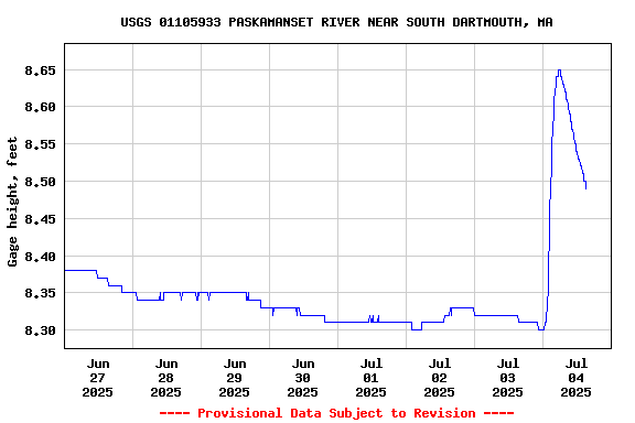
Most recent instantaneous value: 9.65 07-04-2025   12:15 EDT
Graph of  Discharge, cubic feet per second

Add up to 2 more sites and replot for "Discharge, cubic feet per second"

?


Create presentation-quality / stand-alone graph.   Subscribe to WaterAlert      

See this graph on the Monitoring Location Pages


Daily discharge, cubic feet per second -- statistics for Jul 4 based on 29 water years of record more
Min
(2007)
25th
percen-
tile
Most Recent
Instantaneous
Value Jul 4
Median Mean 75th
percen-
tile
Max
(1998)
2.15 3.5 9.65 12 25 38 125


Gage height, feet

Most recent instantaneous value: 8.53 07-04-2025   12:15 EDT
Graph of  Gage height, feet

Add up to 2 more sites and replot for "Gage height, feet"

?


Create presentation-quality / stand-alone graph.   Subscribe to WaterAlert      

See this graph on the Monitoring Location Pages