USGS 05053000 WILD RICE RIVER NR ABERCROMBIE, ND

PROVISIONAL DATA SUBJECT TO REVISION

Click to hidestation-specific text
This station managed by the Grand Forks Field Office.

Available Parameters Available Period
  
1997-10-01  2025-07-18
2007-10-01  2025-07-18
2025-03-20  2025-07-18


 (7)
 

  -- or --


Summary of all available data for this site
Instantaneous-data availability statement


Discharge, cubic feet per second

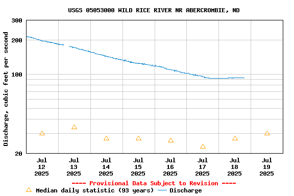
Most recent instantaneous value: 93.3 07-18-2025   19:00 CDT
Graph of  Discharge, cubic feet per second

Add up to 2 more sites and replot for "Discharge, cubic feet per second"

?


Create presentation-quality / stand-alone graph.   Subscribe to WaterAlert      

See this graph on the Monitoring Location Pages


Daily discharge, cubic feet per second -- statistics for Jul 19 based on 93 water years of record more
Min
(1990)
25th
percen-
tile
Median Most Recent
Instantaneous
Value Jul 19
75th
percen-
tile
Mean Max
(2011)
0.00 2.8 30 93.3 168 185 2560


Gage height, feet, [(2)]

Most recent instantaneous value: 10.75 07-18-2025   19:00 CDT
Graph of  Gage height, feet, [(2)]

Add up to 2 more sites and replot for "Gage height, feet, [(2)]"

?


Create presentation-quality / stand-alone graph.   Subscribe to WaterAlert      

See this graph on the Monitoring Location Pages


Stream water level elevation above NAVD 1988, in feet

Most recent instantaneous value: 909.63 07-18-2025   19:00 CDT
Graph of  Stream water level elevation above NAVD 1988, in feet

Add up to 2 more sites and replot for "Stream water level elevation above NAVD 1988, in feet"

?


Create presentation-quality / stand-alone graph.   Subscribe to WaterAlert      

See this graph on the Monitoring Location Pages