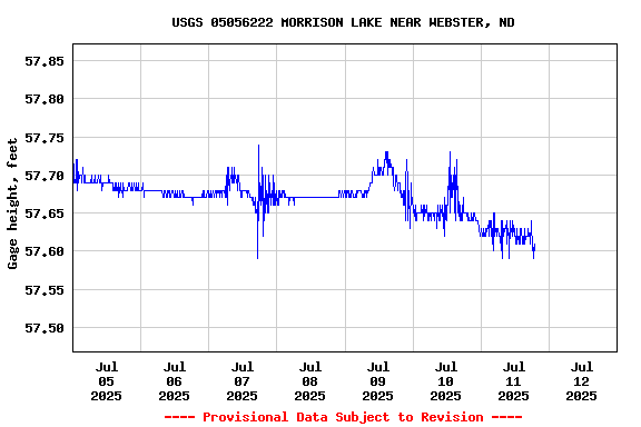
USGS 05056222 MORRISON LAKE NEAR WEBSTER, ND

PROVISIONAL DATA SUBJECT TO REVISION

Click to hidestation-specific text
This station managed by the Grand Forks Field Office.

Available Parameters Available Period
  
2007-10-01  2024-03-28
2023-11-29  2024-03-28


 (7)
 

  -- or --


Summary of all available data for this site
Instantaneous-data availability statement


Gage height, feet

Most recent instantaneous value: 57.57 03-28-2024   17:00 CDT
Graph of  Gage height, feet

Add up to 2 more sites and replot for "Gage height, feet"

?


Create presentation-quality / stand-alone graph.   Subscribe to WaterAlert      

See this graph on the Monitoring Location Pages


Lake or reservoir water surface elevation above NAVD 1988, feet

Most recent instantaneous value: 1458.87 03-28-2024   17:00 CDT
Graph of  Lake or reservoir water surface elevation above NAVD 1988, feet

Add up to 2 more sites and replot for "Lake or reservoir water surface elevation above NAVD 1988, feet"

?


Create presentation-quality / stand-alone graph.   Subscribe to WaterAlert      

See this graph on the Monitoring Location Pages