Funding for this site is provided by:
 STATION.
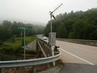
--01541500 CLEARFIELD CREEK AT DIMELING, PA
LOCATION.--Lat 40`58'18", long
78`24'22", Clearfield County, Hydrologic Unit 02050201, on
left bank at downstream side of highway bridge on SR 2024 at Dimeling,
600 ft downstream from Little Clearfield Creek, and 4.0 mi southeast of
Clearfield.
DRAINAGE AREA.--371 square miles.
PERIOD OF RECORD.--October 1913 to current year.
GAGE.--Water-stage recorder and crest-stage gage.
Datum of gage is 1,145.56 ft above North American Vertical Datum of
1988. Prior to Oct. 17, 1928, nonrecording gage, and Oct. 17, 1928, to
Oct. 25, 1967, water-stage recorder at site 200 ft upstream at same
datum. Prior to September 1, 2023, the datum of gage was reported as
1,146.08 ft above National Geodetic Vertical Datum of 1929. Satellite
telemetry at station.
COOPERATION.--Station established and maintained by
the U.S. Geological Survey. Funding for the operation of this station
is provided by the Pennsylvania Department of Environmental Protection
and the U.S. Geological Survey.
GAGE HEIGHTS OF IMPORTANCE.- Operational Limit = 26.7
ft
Supplied by NWS: Flood stage-13 ft.
REMARKS.--Flow regulated since December 1960 by
Glendale Dam (station 01541340) about 25 mi upstream.
