PROVISIONAL DATA SUBJECT TO REVISION
Click to hidestation-specific text
Funding for this site is provided by:
 STATION.--01552500 MUNCY CREEK NEAR SONESTOWN,
PA
STATION.--01552500 MUNCY CREEK NEAR SONESTOWN,
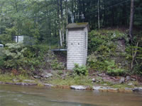
PALOCATION.--Lat 41`21'25", long 76`32'06", Sullivan County, Hydrologic Unit 02050206, on right bank 150 ft downstream from Slip Run, 185 ft downstream from bridge on SR 2002, and 1.2 mi east of Sonestown.
DRAINAGE AREA.--23.8 square miles.
PERIOD OF RECORD.--October 1940 to current year.
GAGE.--Water-stage recorder and crest-stage gage. Datum of gage is 1,025.01 ft above National Geodetic Vertical Datum of 1929. Prior to Mar. 31, 1941, non-recording gage at same site and datum. Satellite telemetry at station.
COOPERATION.--Funding for the operation of this station is provided by the Pennsylvania Department of Environmental Protection and the U.S. Geological Survey.
GAGE HEIGHTS OF IMPORTANCE.-
Supplied by USGS: Data transmitter operational limit - 17.9 ft;
Supplied by NWS: Action stage-5 ft.
Summary of all available data for this site
Instantaneous-data availability statement
