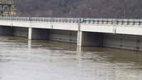
 STATION.
--01576980 SUSQUEHANNA RIVER AT HOLTWOOD DAM
AT HOLTWOOD, PA
WATER QUALITY DATA IS NOT TRANSMITTED VIA
SATELLITE TELEMETRY AND THEREFORE WILL ONLY BE UPDATED ABOUT EVERY 6
WEEKS.
LOCATION.--Lat 39`49'40", long
76`20'01", Lancaster County, Hydrologic Unit 02050306, along
inner skimmer wall at Holtwood Dam located on Holtwood Road about 0.5
mi southwest of town of Holtwood, PA.
DRAINAGE AREA.--26,740 square miles.
PERIOD OF RECORD.--April 2015 to October 2018.
GAGE.--Continuous water-quality monitor measuring
turbidity, specific conductance and water temperature.
COOPERATION.--Funding for the operation of this
station is provided by the Exelon Corporation, the Maryland Department
of Natural Resources and the U.S. Geological Survey.
 STATION.--01576980 SUSQUEHANNA RIVER AT HOLTWOOD DAM
AT HOLTWOOD, PA