Warning: Javascript must be enabled to use all the features on this page!
Page Loading - Please Wait...
Click to hideNews Bulletins
Explore the NEWUSGS National Water Dashboard interactive map to access real-time water data from over 13,500 stations nationwide.
This page is undergoing modernization and will be decommissioned in the future.
Daily data are now available in WDFN.
Try it out and tell us what you think at wdfn@usgs.gov
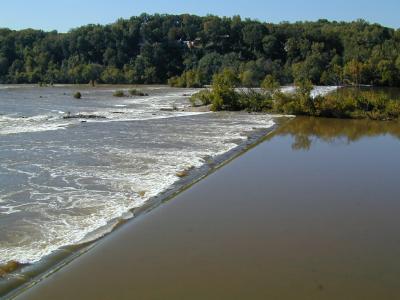
USGS 01646500 POTOMAC RIVER NEAR WASH, DC LITTLE FALLS PUMP STA
LOCATION.--Lat
38°56'59.2", long 77°07'39.5", Montgomery County, MD,
Hydrologic Unit 02070008, on left bank just upstream from Little Falls
Dam, 1 mi upstream from District of Columbia boundary line, 1.2 mi
upstream from Chain Bridge, 1.8 mi east of Langley, Fairfax County, and
at mile 117.4. DRAINAGE AREA.--11,560 mi2. REVISIONS HISTORY.--
Discharge for Measurement 385 made on 06/25/2021
was revised on 09/22/2021 due to an error in computation.
PERIOD OF RECORD.--March 1930 to current
year. GAGE.--Water-stage recorder, crest-stage gage, and concrete
control. Datum of gage is 37.20 ft above North American Vertical Datum
of 1988. Prior to Jun 7, 1930, nonrecording gage, and June 7, 1930 to
Jan. 22, 1965, water-stage recorder at site 1 mi upstream on right bank
at same gage datum. REMARKS.--Diversions since June 1959. U.S. Geological Survey
satellite data-collection platform at station. EXTREMES OUTSIDE PERIOD OF RECORD.--Flood of June 2, 1889, was
of approximately the same magnitude as that of March 19, 1936. COOPERATION.--Funding for the operation of this station is
provided by the U.S. Geological Survey. Access to gage site provided by
the Baltimore District, U.S. Army Corps of Engineers.