USGS 09180000 DOLORES RIVER NEAR CISCO, UT

PROVISIONAL DATA SUBJECT TO REVISION

Click to hidestation-specific text
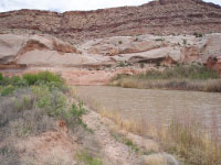
USGS station 09180000

Dolores River at 8.50 feet gage height and 973 cubic feet per second.


Station operated by the U.S. Geological Survey as part of the Federal Priority Streamgages Network, in cooperation with the U.S. Bureau of Reclamation.

Logo for USGS Real-time Water Quality Visit USGS Real-Time Water Quality to view continuous estimates of concentrations and loads for bacteria and other chemicals.
This station managed by the Moab UT Field Office.

Available Parameters Available Period
  
2007-10-01  2024-11-27
2018-08-15  2024-11-27
1986-10-01  2024-11-27
2007-10-01  2024-11-27
2007-10-01  2024-11-27


 (7)
 

  -- or --


Summary of all available data for this site
Instantaneous-data availability statement


Temperature, water, degrees Celsius

Most recent instantaneous value: 4.2 11-27-2024   11:00 MST
Graph of  Temperature, water, degrees Celsius

Add up to 2 more sites and replot for "Temperature, water, degrees Celsius"

?


Create presentation-quality / stand-alone graph.   Subscribe to WaterAlert      

See this graph on the Monitoring Location Pages


Specific conductance, water, unfiltered, microsiemens per centimeter at 25 degrees Celsius

Most recent instantaneous value: 1680 11-27-2024   11:00 MST
Graph of  Specific conductance, water, unfiltered, microsiemens per centimeter at 25 degrees Celsius

Add up to 2 more sites and replot for "Specific conductance, water, unfiltered, microsiemens per centimeter at 25 degrees Celsius"

?


Create presentation-quality / stand-alone graph.   Subscribe to WaterAlert      

See this graph on the Monitoring Location Pages