PROVISIONAL DATA SUBJECT TO REVISION
Click to hidestation-specific text
 STATION.--01427195 EQUINUNK CREEK NEAR DILLONTOWN,
PA
STATION.--01427195 EQUINUNK CREEK NEAR DILLONTOWN,
PALOCATION.--Lat 41`50'25", long 75`14'18", Wayne County, Hydrologic Unit 02040101, at bridge 1,688 ft upstream from South Branch Equinunk Creek, and 1.72 mi above mouth and Equinunk.
DRAINAGE AREA.--46.9 square miles.
PERIOD OF RECORD.--September 2018 to current year.
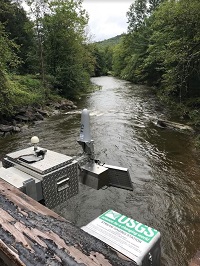
GAGE.--Water-stage recorder, non-contact stage sensor, water temperature sensor and crest-stage gage. Datum of gage is 913.1 ft above North American Vertical Datum of 1988. Satellite telemetry at station. Prior to November 9, 2022 the datum of gage was erroneously reported as 913.5 ft above NAVD88.
COOPERATION.--Funding for the operation of this station is provided by the U.S. Geological Survey.
REMARKS.--Computed discharge below 60 cfs and above 600 cfs are considered poor due to lack of measurement data while ratings are being developed and may change substantially after review.
Summary of all available data for this site
Instantaneous-data availability statement
