PROVISIONAL DATA SUBJECT TO REVISION
Click to hidestation-specific text
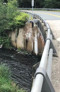 STATION.--01432495 SHOHOLA CREEK NEAR WALKER LAKE,
PA
STATION.--01432495 SHOHOLA CREEK NEAR WALKER LAKE,
PALOCATION.--Lat 41`27'00", long 74`55'18", referenced to Noth American Datum of 1983, Pike County, Hydrologic Unit 02040104, at bridge on Knealing Road, 900 ft east of State Route 434 and 0.4 miles south of intersection of Knealing Road and Twin Lakes Road.
DRAINAGE AREA.--74.5 square miles.
PERIOD OF RECORD.--September 2018 to current year.
GAGE.--Water-stage recorder, non-contact stage sensor, and crest-stage gage. Datum of gage is 691.1 ft above North American Vertical Datum of 1988. Satellite telemetry at station. Prior to November 10, 2022, the datum of gage was erroneously reported as 710 or 691.3 ft above NAVD88.
COOPERATION.--Funding for the operation of this station is provided by the U.S. Geological Survey.
REMARKS.--Computed discharge below 50 cfs and above 500 cfs are considered poor due to lack of measurement data while ratings are being developed and may change substantially after review.
Summary of all available data for this site
Instantaneous-data availability statement
