USGS 06471000 JAMES RIVER AT COLUMBIA,SD

PROVISIONAL DATA SUBJECT TO REVISION

This station managed by the Huron Studies Office.

Available Parameters Available Period
  
1991-04-27  2025-07-08
2018-04-24  2025-07-08
2025-03-10  2025-07-08


 (7)
 

  -- or --


Summary of all available data for this site
Instantaneous-data availability statement


Discharge, cubic feet per second

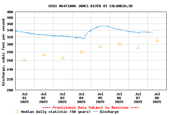
Most recent instantaneous value: 334 07-08-2025   06:00 CDT
Graph of  Discharge, cubic feet per second

Add up to 2 more sites and replot for "Discharge, cubic feet per second"

?


Create presentation-quality / stand-alone graph.   Subscribe to WaterAlert      

See this graph on the Monitoring Location Pages


Daily discharge, cubic feet per second -- statistics for Jul 8 based on 50 water years of record more
Min
(1977)
25th
percen-
tile
Median Most Recent
Instantaneous
Value Jul 8
Mean 75th
percen-
tile
Max
(2011)
0.00 59 310 334 648 1130 3290


Gage height, feet

Most recent instantaneous value: 8.00 07-08-2025   06:00 CDT
Graph of  Gage height, feet

Add up to 2 more sites and replot for "Gage height, feet"

?


Create presentation-quality / stand-alone graph.   Subscribe to WaterAlert      

See this graph on the Monitoring Location Pages


Stream water level elevation above NAVD 1988, in feet

Most recent instantaneous value: 1281.17 07-08-2025   06:00 CDT
Graph of  Stream water level elevation above NAVD 1988, in feet

Add up to 2 more sites and replot for "Stream water level elevation above NAVD 1988, in feet"

?


Create presentation-quality / stand-alone graph.   Subscribe to WaterAlert      

See this graph on the Monitoring Location Pages