USGS 07081200 ARKANSAS RIVER NEAR LEADVILLE, CO

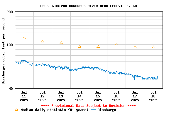
PROVISIONAL DATA SUBJECT TO REVISION

Click to hidestation-specific text
Click for larger image

Station operated by the U.S. Geological Survey in cooperation with Bureau of Reclamation.

Current shift adjusted rating table.
What is a shift adjusted stage-discharge rating table?

Boating safety tips

This station managed by the Pueblo Southeast Colorado Office.

Available Parameters Available Period
  
1990-04-25  2023-12-10
2020-11-02  2023-12-10


 (7)
 

  -- or --


Summary of all available data for this site
Instantaneous-data availability statement


Discharge, cubic feet per second

Most recent instantaneous value: Ice 12-10-2023   19:15 MST
Graph of  Discharge, cubic feet per second

Add up to 2 more sites and replot for "Discharge, cubic feet per second"

?


Create presentation-quality / stand-alone graph.   Subscribe to WaterAlert      

See this graph on the Monitoring Location Pages


Daily discharge, cubic feet per second -- statistics for Dec 10 based on 49 water years of record more
Most Recent
Instantaneous
Value Dec 10
Min
(1977)
25th
percen-
tile
Mean Median 75th
percen-
tile
Max
(1983)
-- unavailable -- 12.0 15 18 18 20 25.0


Gage height, feet

Most recent instantaneous value: 5.95 12-10-2023   19:15 MST
Graph of  Gage height, feet

Add up to 2 more sites and replot for "Gage height, feet"

?


Create presentation-quality / stand-alone graph.   Subscribe to WaterAlert      

See this graph on the Monitoring Location Pages