LOCATION.--Lat 40°39'41", long
73°57'43" referenced to North American Datum of 1927,
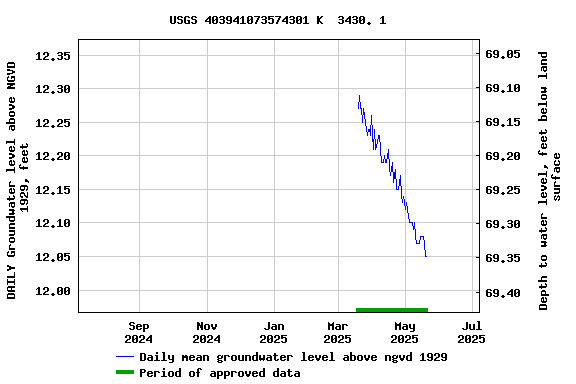
Kings County, NY, Hydrologic Unit 02030201,
WELL CHARACTERISTICS.--Depth 120 ft. Upper casing
diameter 4 in; top of first opening 100 ft, bottom of last
opening 110 ft.
DATUM.--Land-surface datum is 81.4 ft above National
Geodetic Vertical Datum of 1929. Measuring point: unknown,
81.26 ft above land-surface datum, Sep. 5, 1996 to
present.
PERIOD OF RECORD.--April 1996 to June 2000, September
2007 to April 2015, July 2024 to current year.
GAGE.--Periodic manual measurements by USGS
personnel.
EXTREMES FOR PERIOD OF RECORD.--Highest water level
measured, 11.99 ft above NGVD of 1929, Jan. 25, 2012; lowest
measured, 9.05 ft above NGVD of 1929, Mar. 23, 2000.
 Site Information
 WaterAlert – get an
email or text (SMS) alert based on your chosen threshold.
WaterAlert – get an
email or text (SMS) alert based on your chosen threshold. Station image