LOCATION.--Lat 40°40'39", long
73°55'50" referenced to North American Datum of 1927,
Kings County, NY, Hydrologic Unit 02030201, at east side of
Utica Avenue, 54 ft north of Atlantic Avenue, northernmost
well, Bedford-Stuyvesant.
WELL CHARACTERISTICS.--Depth 360 ft. Upper casing
diameter 4 in; top of first opening 330 ft, bottom of last
opening 350 ft.
DATUM.--Land-surface datum is 61.8 ft above National
Geodetic Vertical Datum of 1929. Measuring point: Top of
casing, 0.09 ft below land-surface datum, 61.71 ft above
land-surface datum, Mar. 14, 1995 to present.
PERIOD OF RECORD.--March 1995 to April 2015, June 2024
to current year.
GAGE.--Periodic manual measurements by USGS
personnel.
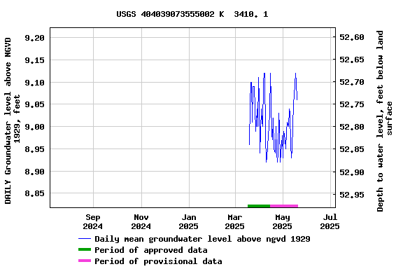
EXTREMES FOR PERIOD OF RECORD.--Highest water level
measured, 9.87 ft above NGVD of 1929, May 25, 2011; lowest
measured, 5.59 ft above NGVD of 1929, Aug. 17, 1999.
 Site Information
 WaterAlert – get an
email or text (SMS) alert based on your chosen threshold.
WaterAlert – get an
email or text (SMS) alert based on your chosen threshold. Station image