LOCATION.--Lat 40°43'37.1", long
73°54'01.9" referenced to North American Datum of
1983, Queens County, NY, Hydrologic Unit 02030201, at north
side of 55th Avenue, 50 ft west of 65th Place, Maspeth.
WELL CHARACTERISTICS.--Depth 24 ft. Upper casing
diameter 2 in; top of first opening 14.4 ft, bottom of last
opening 24.4 ft.
DATUM.--Land-surface datum is 53.7 ft above National
Geodetic Vertical Datum of 1929. Measuring point: Top of
casing, 0.06 ft below land-surface datum, 53.64 ft above
land-surface datum, Jul. 29, 1999 to present.
PERIOD OF RECORD.--August 1999 to April 2015, April 2024
to current year.
GAGE.--Periodic manual measurements by USGS
personnel.
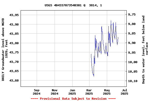
EXTREMES FOR PERIOD OF RECORD.--Highest water level
measured, 44.16 ft above NGVD of 1929, Apr. 5, 2010, Aug. 16,
2011; lowest measured, 43.07 ft above NGVD of 1929, Feb. 26,
2002.
 Site Information
 WaterAlert – get an
email or text (SMS) alert based on your chosen threshold.
WaterAlert – get an
email or text (SMS) alert based on your chosen threshold. Station image