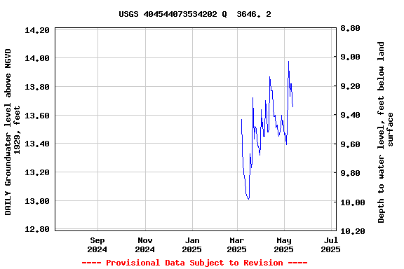
LOCATION.--Lat 40°45'44.2", long
73°53'40.3" referenced to North American Datum of
1983, Queens County, NY, Hydrologic Unit 02030201,
WELL CHARACTERISTICS.--Depth 35.3 ft. Upper casing
diameter 2 in; top of first opening 25.3 ft, bottom of last
opening 30.3 ft.
DATUM.--Land-surface datum is 23 ft above National
Geodetic Vertical Datum of 1929. Measuring point: Top of
casing, 0.07 ft below land-surface datum, 22.93 ft above
land-surface datum, Oct. 1, 2002 to present.
PERIOD OF RECORD.--March 2003 to April 2015, May 2024 to
current year.
GAGE.--Periodic manual measurements by USGS
personnel.
REMARKS.--Replaced well Q3646.1 near same
location.
EXTREMES FOR PERIOD OF RECORD.--Highest water level
measured, 15.02 ft above NGVD of 1929, Apr. 21, 2015; lowest
measured, 13.26 ft above NGVD of 1929, Mar. 17, 2004.
 Site Information
 WaterAlert – get an
email or text (SMS) alert based on your chosen threshold.
WaterAlert – get an
email or text (SMS) alert based on your chosen threshold. Station image