LOCATION.--Lat 40°46'16.8", long
73°48'29.8" referenced to North American Datum of
1983, Queens County, NY, Hydrologic Unit 02030201, at south
side of 29th Avenue, south of intersection with 156th Court, at
north side of Bowne Park, Flushing.
WELL CHARACTERISTICS.--Depth 90 ft. Upper casing
diameter 2 in; top of first opening 80 ft, bottom of last
opening 85 ft.
DATUM.--Land-surface datum is 91 ft above National
Geodetic Vertical Datum of 1929. Measuring point: Top of
casing, 0.08 ft below land-surface datum, 90.92 ft above
land-surface datum, Jul. 27, 1999 to present.
PERIOD OF RECORD.--August 1999 to April 2015, April 2024
to current year.
GAGE.--Periodic manual measurements by USGS
personnel.
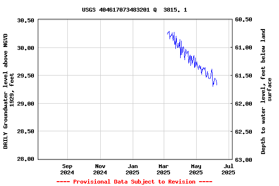
EXTREMES FOR PERIOD OF RECORD.--Highest water level
measured, 31.43 ft above NGVD of 1929, Jan. 31, 2012; lowest
measured, 26.09 ft above NGVD of 1929, Oct. 23, 2002.
 Site Information
 WaterAlert – get an
email or text (SMS) alert based on your chosen threshold.
WaterAlert – get an
email or text (SMS) alert based on your chosen threshold. Station image