LOCATION.--Lat 40°40'31", long
73°38'27" referenced to North American Datum of 1927,
Nassau County, NY, Hydrologic Unit 02030202, at west side of
North Village Avenue, 54 ft north of Demott Avenue, Rockville
Centre.
WELL CHARACTERISTICS.--Depth 645 ft. Upper casing
diameter 4 in; top of first opening 620 ft, bottom of last
opening 640 ft. Datum of gage is NGVD of 1929.
DATUM.--Land-surface datum is 36 ft above National
Geodetic Vertical Datum of 1929. Measuring point: Top of
coupling, 0.14 ft below land-surface datum, 35.86 ft above
land-surface datum, Oct. 3, 1988 to Jun. 24, 2015; Top of 4 in.
steel casing, north edge, 35.67 ft above land-surface datum,
Jun. 23, 2015 to Oct. 23, 2023; New MP. Removed blue riser,
35.63 ft above land-surface datum, Feb. 8, 2019 to Oct. 23,
2023; Top of 4 in. steel casing, north edge, 35.674 ft above
land-surface datum, Oct. 23, 2023 to present.
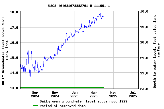
PERIOD OF RECORD.--March 1993 to March 1998, September
2003 to current year.
GAGE.--Water-level recorder installed September 2003 to
August 2024; 15-minute recording interval. Periodic manual
measurements made by USGS personnel.
EXTREMES FOR PERIOD OF RECORD.--Highest water level
recorded, 21.01 ft above NGVD of 1929, Apr. 3, 2010; lowest
recorded, 12.14 ft above NGVD of 1929, Aug. 30, 2016.
 Site Information
 WaterAlert – get an
email or text (SMS) alert based on your chosen threshold.
WaterAlert – get an
email or text (SMS) alert based on your chosen threshold.