LOCATION.--Lat 40°41'12", long
73°50'09" referenced to North American Datum of 1927,
Queens County, NY, Hydrologic Unit 02030202, at west side of
108th Street, 196 ft south of 101st Avenue, Woodhaven.
WELL CHARACTERISTICS.--Depth 65 ft. Upper casing
diameter 2 in; top of first opening 60 ft, bottom of last
opening 65 ft.
DATUM.--Land-surface datum is 46 ft above National
Geodetic Vertical Datum of 1929. Measuring point: Top of
coupling, 0.78 ft below land-surface datum, 45.22 ft above
land-surface datum, Mar. 2, 1984 to present.
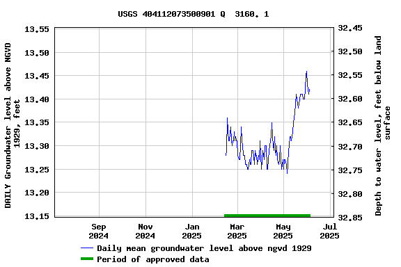
PERIOD OF RECORD.--March 1984 to August 2014, May 2024
to current year.
GAGE.--Water level recorder installed May 1998 to
September 2010. Periodic manual measurements by USGS
personnel.
REMARKS.--Water level affected by local
dewatering.
EXTREMES FOR PERIOD OF RECORD.--Highest water level
recorded, 14.96 ft above NGVD of 1929, Apr. 26, 2010; lowest
measured, 6.08 ft above NGVD of 1929, Mar. 2, 1984.
 Site Information
 WaterAlert – get an
email or text (SMS) alert based on your chosen threshold.
WaterAlert – get an
email or text (SMS) alert based on your chosen threshold. Station image