LOCATION.--Lat 40°49'00.5", long
73°19'38.0" referenced to North American Datum of
1983, Suffolk County, NY, Hydrologic Unit 02030202, at Dix
Hills Park and Golf Course, 180 ft west of DeForest Road, 154
ft north of parking lot, northernmost well, Dix Hills.
WELL CHARACTERISTICS.--Depth 740 ft. Upper casing
diameter 4 in; top of first opening 730 ft, bottom of last
opening 735 ft.
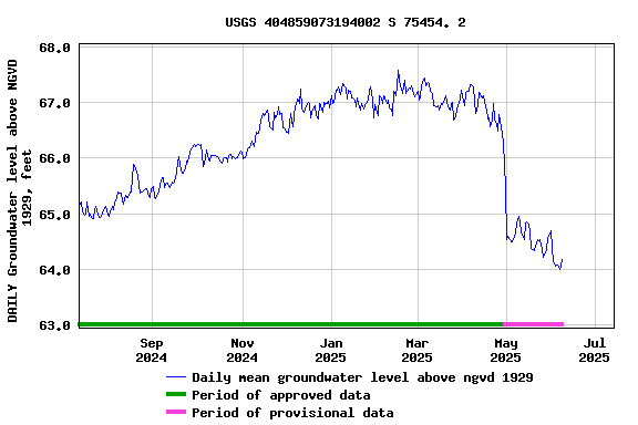
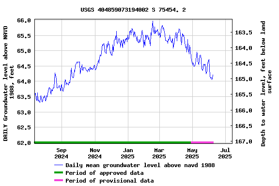
DATUM.--Land-surface datum is 230.7 ft above National
Geodetic Vertical Datum of 1929. Measuring point: Top of
casing, 0.14 ft below land-surface datum, 230.56 ft above
land-surface datum, Mar. 27, 1984 to present.
PERIOD OF RECORD.--March 1984 to current year.
GAGE.--Water level recorder installed February 2020.
Periodic manual measurements by USGS personnel.
EXTREMES FOR PERIOD OF RECORD.--Highest water level
measured, 74.05 ft above NGVD of 1929, Mar. 21, 1991; lowest
recorded, 60.46 ft above NGVD of 1929, Sept. 8, 2023.
 Site Information
 WaterAlert – get an
email or text (SMS) alert based on your chosen threshold.
WaterAlert – get an
email or text (SMS) alert based on your chosen threshold. Station image