PROVISIONAL DATA SUBJECT TO REVISION
Click to hidestation-specific text
Funding for this site is provided by:
 Site Information
LOCATION.--Lat 42°26'45", long
76°30'44" referenced to North American Datum of 1983,
Tompkins County, NY, Hydrologic Unit 04140201, on left bank of
old inlet channel, in vestibule of restaurant, 200 ft upstream
from flood-control channel of Cayuga Inlet, at north end of
Taughannock Boulevard, at Ithaca.
DRAINAGE AREA.--143 mi². (Cayuga Inlet), Cayuga Lake at mouth 1,564 mi²; Cayuga Lake portion 785 mi².
PERIOD OF RECORD.--August 1905 to December 1909 in reports of Geological Survey. January 1910 to September 1925 in reports of State Engineer and Surveyor. August 1956 to current year.
REVISIONS HISTORY.--WSP 2112: Drainage area. Elevation record from Oct. 1, 1977 to Jan. 19, 2023 and the maximum elevation for the period of record, was revised on Mar. 1, 2023 based on an updated geodetic survey.
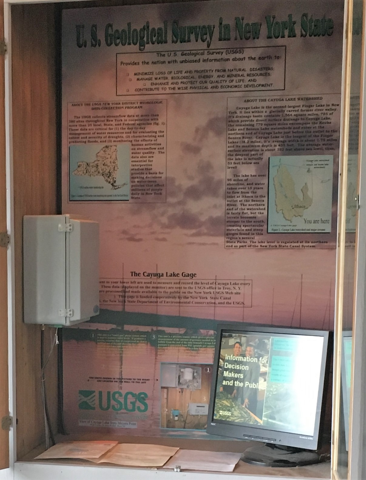
GAGE.--Water-stage recorder and crest-stage gage. Lake elevation record is provided in NGVD of 1929 and NAVD of 1988 datums. To convert NGVD of 1929 elevations to Barge Canal datum, add 1.43 ft. To convert NGVD of 1929 elevations to NAVD of 1988, subtract 0.62 ft. Prior to September 1925, nonrecording gages at several sites within 1 mi of present site. August 1956 to September 2000, at site 100 ft downstream.
REMARKS.--Lake elevation regulated at north end of lake by dam and Lock 1 (Mud Lock) on Cayuga-Seneca Canal. Area of water surface, 66.9 mi². Seneca River (Cayuga-Seneca Canal) enters lake 0.5 mi upstream from Mud Lock and is included in second drainage area given above.
EXTREMES FOR PERIOD OF RECORD.--Maximum elevation, 386.33 ft above NGVD of 1929 (385.71 ft above NAVD of 1988), June 26, 1972; minimum elevation not determined; minimum daily elevation, 377.64 ft above NGVD of 1929 (377.02 ft above NAVD of 1988), Mar. 28, 1960.
DRAINAGE AREA.--143 mi². (Cayuga Inlet), Cayuga Lake at mouth 1,564 mi²; Cayuga Lake portion 785 mi².
PERIOD OF RECORD.--August 1905 to December 1909 in reports of Geological Survey. January 1910 to September 1925 in reports of State Engineer and Surveyor. August 1956 to current year.
REVISIONS HISTORY.--WSP 2112: Drainage area. Elevation record from Oct. 1, 1977 to Jan. 19, 2023 and the maximum elevation for the period of record, was revised on Mar. 1, 2023 based on an updated geodetic survey.
GAGE.--Water-stage recorder and crest-stage gage. Lake elevation record is provided in NGVD of 1929 and NAVD of 1988 datums. To convert NGVD of 1929 elevations to Barge Canal datum, add 1.43 ft. To convert NGVD of 1929 elevations to NAVD of 1988, subtract 0.62 ft. Prior to September 1925, nonrecording gages at several sites within 1 mi of present site. August 1956 to September 2000, at site 100 ft downstream.
REMARKS.--Lake elevation regulated at north end of lake by dam and Lock 1 (Mud Lock) on Cayuga-Seneca Canal. Area of water surface, 66.9 mi². Seneca River (Cayuga-Seneca Canal) enters lake 0.5 mi upstream from Mud Lock and is included in second drainage area given above.
EXTREMES FOR PERIOD OF RECORD.--Maximum elevation, 386.33 ft above NGVD of 1929 (385.71 ft above NAVD of 1988), June 26, 1972; minimum elevation not determined; minimum daily elevation, 377.64 ft above NGVD of 1929 (377.02 ft above NAVD of 1988), Mar. 28, 1960.
 WaterAlert – get an
email or text (SMS) alert based on your chosen threshold.
WaterAlert – get an
email or text (SMS) alert based on your chosen threshold.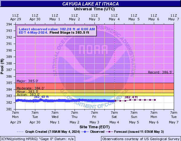
 Station image
Summary of all available data for this site
Instantaneous-data availability statement

