USGS 14137000 SANDY RIVER NEAR MARMOT, OR

PROVISIONAL DATA SUBJECT TO REVISION

Click to hidestation-specific text

Station operated in cooperation with the U.S. Geological Survey National Streamflow Information Program (NSIP).

NOTE: River forecasts and additional data can be obtained at the 
National Weather Service's Advanced Hydrologic Prediction Services web page.
Boating safety tips
Available Parameters Available Period
  
1987-10-01  2025-07-11
2008-10-01  2025-07-11


 (7)
 

  -- or --


Summary of all available data for this site
Instantaneous-data availability statement


Discharge, cubic feet per second

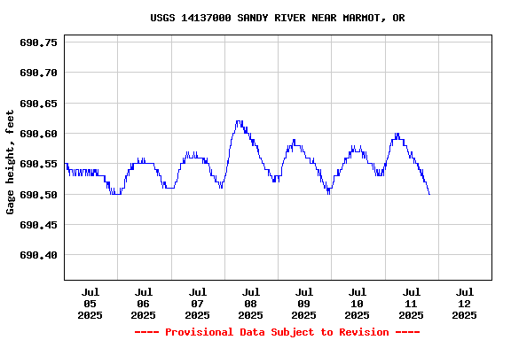
Most recent instantaneous value: 400 07-11-2025   20:15 PDT
Graph of  Discharge, cubic feet per second

Add up to 2 more sites and replot for "Discharge, cubic feet per second"

?


Create presentation-quality / stand-alone graph.   Subscribe to WaterAlert      

See this graph on the Monitoring Location Pages


Daily discharge, cubic feet per second -- statistics for Jul 12 based on 112 water years of record more
Min
(2015)
Most Recent
Instantaneous
Value Jul 12
25th
percen-
tile
Median Mean 75th
percen-
tile
Max
(1917)
312 400 513 610 649 748 1480


Gage height, feet

Most recent instantaneous value: 690.50 07-11-2025   20:15 PDT
Graph of  Gage height, feet

Add up to 2 more sites and replot for "Gage height, feet"

?


Create presentation-quality / stand-alone graph.   Subscribe to WaterAlert      

See this graph on the Monitoring Location Pages