PROVISIONAL DATA SUBJECT TO REVISION
Click to hidestation-specific text
Funding for this site is provided by:
 STATION.--01471000 TULPEHOCKEN CREEK NEAR READING,
PA
STATION.--01471000 TULPEHOCKEN CREEK NEAR READING,
PALOCATION.--Lat 40`22'08", long 75`58'46", Berks County, Hydrologic Unit 02040203, on right bank 15 ft upstream from covered bridge on Township Route 921, 1.0 mi downstream from Cacoosing Creek, 2.5 mi upstream from mouth, and 3.5 mi northwest of town square in Reading.
DRAINAGE AREA.--211 square miles.
PERIOD OF RECORD.--October 1950 to current year.
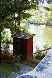
GAGE.--Water-stage recorder and crest-stage gage. Datum of gage is 216.60 ft above National Geodetic Vertical Datum of 1929. Satellite telemetry at station.
COOPERATION.--Funding for the operation of this station is provided by the U.S. Army Corps of Engineers, Philadelphia District and the Pennsylvania Department of Environmental Protection.
REMARKS.--Flow regulated since April 1979 by Blue Marsh Lake (station 01470870), 3.9 mi upstream.
GAGE HEIGHTS OF IMPORTANCE.-
Supplied by USGS: Data transmitter operational limit: 17.4 ft;
Supplied by NWS: Action stage: 9 ft; Flood stage: 10.5 ft; Moderate flood stage: 12 ft; Major flood stage: 14 ft;
Summary of all available data for this site
Instantaneous-data availability statement

