USGS 13012475 South Fork Spread Cr at mouth, nr Moran, WY

PROVISIONAL DATA SUBJECT TO REVISION

Click to hidestation-specific text

UPDATED July 25, 2022: This station is part of a short-term project and is scheduled to be discontinued on September 30, 2022 if alternative funding can not be secured.
Historic information will continue be available from the USGS.
Please contact the (Wyoming-Montana Science Center) for more information.
This station managed by the Riverton Field Unit.

Available Parameters Available Period
  
2018-09-20  2023-07-29
2018-09-20  2023-07-29
2018-09-20  2023-07-29


 (3)
 

  -- or --


Summary of all available data for this site
Instantaneous-data availability statement


Temperature, water, degrees Celsius

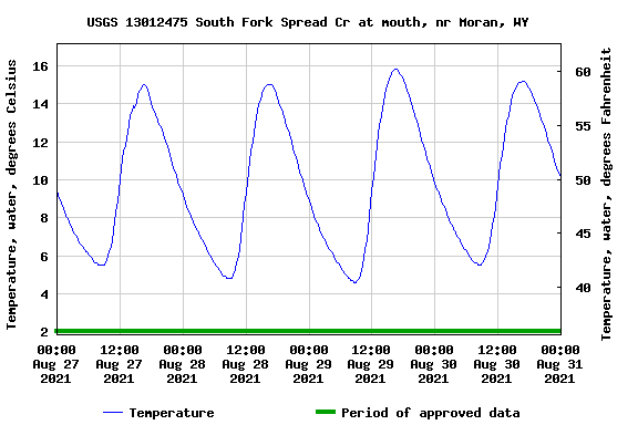
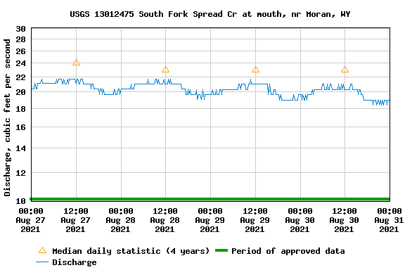
Most recent instantaneous value: 19.2 07-29-2023   16:15 MDT
Graph of  Temperature, water, degrees Celsius

Add up to 2 more sites and replot for "Temperature, water, degrees Celsius"

?


Create presentation-quality / stand-alone graph.   Subscribe to WaterAlert      

See this graph on the Monitoring Location Pages


Discharge, cubic feet per second

Most recent instantaneous value: 30.8 07-29-2023   16:15 MDT
Graph of  Discharge, cubic feet per second

Add up to 2 more sites and replot for "Discharge, cubic feet per second"

?


Create presentation-quality / stand-alone graph.   Subscribe to WaterAlert      

See this graph on the Monitoring Location Pages


Gage height, feet

Most recent instantaneous value: 2.25 07-29-2023   16:15 MDT
Graph of  Gage height, feet

Add up to 2 more sites and replot for "Gage height, feet"

?


Create presentation-quality / stand-alone graph.   Subscribe to WaterAlert      

See this graph on the Monitoring Location Pages